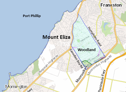
 Mt Eliza Woodland is an area of 7 sq km (700,000 hectares), bounded by Nepean Highway, Canadian Bay Road, Moorooduc Highway and Humphries Road, Mount Eliza.
Woodland covers about one third of Mt Eliza’s area. It represents an early part of the development of Mt Eliza, envisaged as a place where people would live on large blocks, surrounded by nature.
There are still many large trees and areas of remnant bush, especially along the creek reserves, in the Moorooduc Quarry Flora & Fauna Reserve, both in the southwest corner of Woodland, and in Lorikeet Reserve, in the northwest. There is also the extensive Bellbird/Millbank Reserve, which runs along and extends from a creek emptying into Kackeraboite Creek. This reserve offers more than 2 km of walking tracks. All of these reserves are frequented by the many native bird species found in the area.
In order to preserve the unique qualities of the area, Woodland is subject to special planning restrictions. This includes minimum residential housing block sizes, building height restrictions and limits on the area of impermeable cover allowed on each block.
With the challenges we all face with the changing climate, it is ever more important that we protect and even increase the urban tree cover. There are many challenges to this, including the clearing of blocks for housing development and the ever-hungry )protected) possums. Planting new trees and protecting existing ones though banding are things we can all do. The Shire has information available at Protecting Eucalypt Trees [external site] and interactive biodiversity mapping can be found at Biodiversity Mapping Online [external site] .
Earlier this year, Frankston Council hosted a webinar with Dr Greg Moore of Burnley Horticulture College. The subject was ‘Why preserve urban and old trees?’ The webinar recording can be viewed here,[external site] using the passcode 5qd!i6e& .
If you are new to Woodland, we invite you to download our welcome pack [15 MB]
Under the ‘Mt Eliza Woodland’ menu, we also offer links to information about preserving and improving our local environment and other subjects related to living here:
Mornington Peninsula Beekeeping Association
[this page was last updated at 8:45 pm on 13 October 2025]